Route – Off: Castellterçol a Orís (76km)

This route is based on a track from the website Moterus, created by Miguel 650, with an extra segment added at the beginning between Castellterçol and Collsuspina by a mate who is a walking atlas when it comes to offroad routes. Gràcies Ricard!

We meet at 8:30 in a bar called Can Joan on the C-59 just outside Caldes. We were supposed to meet in the Bar Olimpo, a regular meeting point for cyclists and bikers alike, but we found it closed on vacation. After a generously-sized sandwich and coffee, we hit the road.

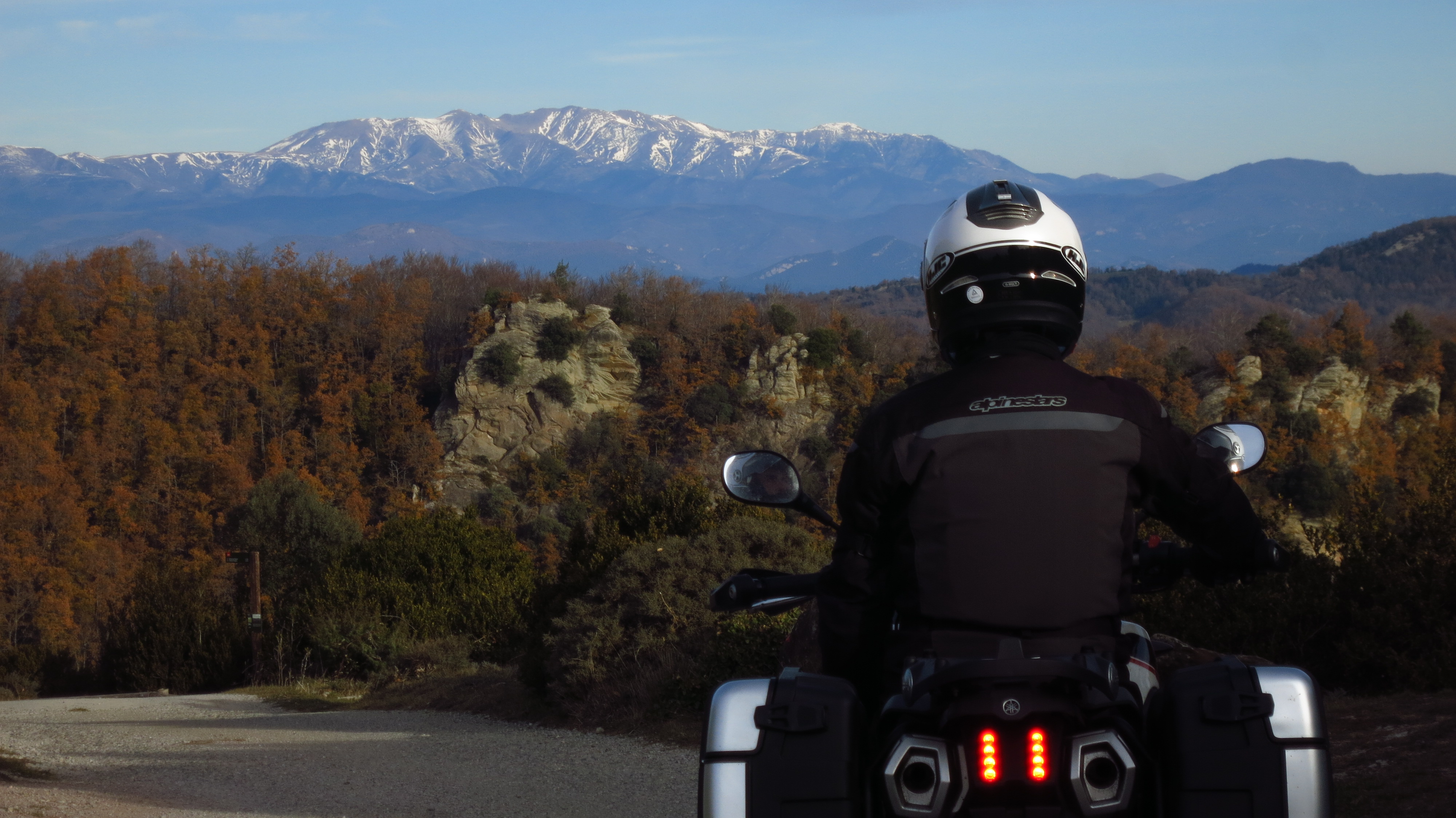
The route that I have programmed in the GPS starts in the outskirts of Moià, heading for Tona, but Ricard suggests approaching the starting point through a track he knows to warm up. Outside Castellterçol there is a small industrial estate called El Vapor, where the track starts between to warehouses. After a short stop to disconnect the ABS and the TCS, the first two members of today’s group shoot off leaving a cloud of dust in their wake. Clearly, they were craving a bit of offroad action… I have no experience in enduro and I do not usually ride dirt tracks on purpose, rather end up in them, but since I got the new motorbike I have been exploring more and more its possibilities, which are far greater than my offroad skills, to tell the truth. The group I am with today, in contrast, have extensive experience on the brown stuff, so I am in for a crash course (literally).

img-20160918-wa0021

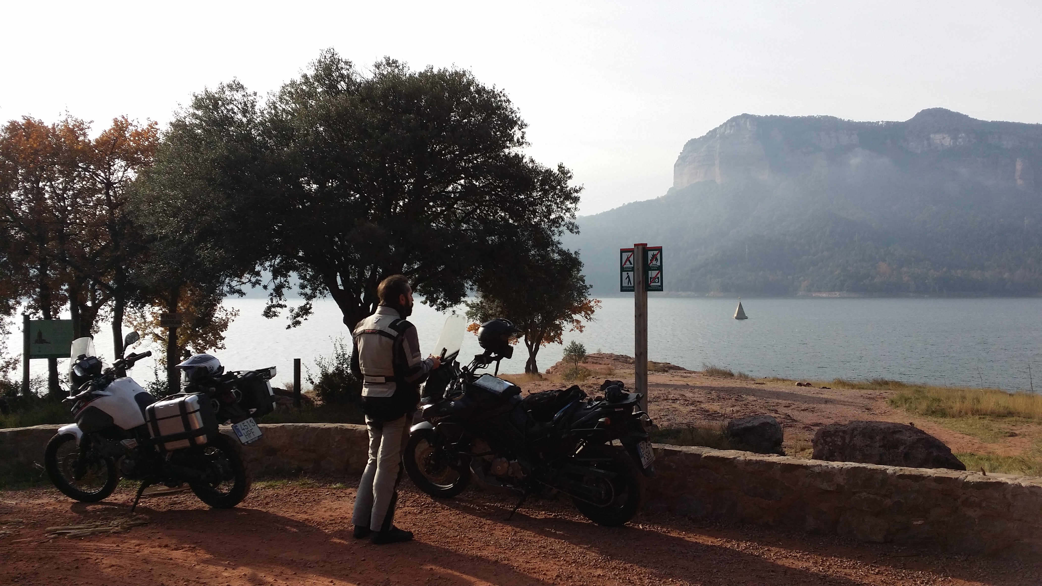
The track connects Castellterçol and Collsuspina through fields and is quite flat and easy, in fact it is accessible by car without trouble. Once there, we head west on tarmac for about 5 kilometres until we reach the beginning of the track I have uploaded on my GPS, right outside Moià. The first part of the route is an uphill track through the forest which, after a few tight corners, opens up to faster sections, always with good surface and good visibility, allowing fast progress. A few kilometres further, though, we have to slow down a bit as we see signs of what seems to be a MTB race or event and, sure enough, a bit later we start coming across bicycles heading the opposite way. We ride this bit slowly, and after a short stop to admire the views, leave behind the MTB course and have the track to ourselves until we reach the BV-4316 road just over some tunnels in the C-25.

img-20160918-wa0020

After crossing the road, another short track segment brings us to the C-62 main road. At first it seems that we have to ride tarmac for a while, but then we discover a service track that runs parallel to the road, crossing it here and there, allowing us to stay on the brown stuff until the B-433, where the route takes us inevitably on tarmac until Sant Bartomeu del Grau.

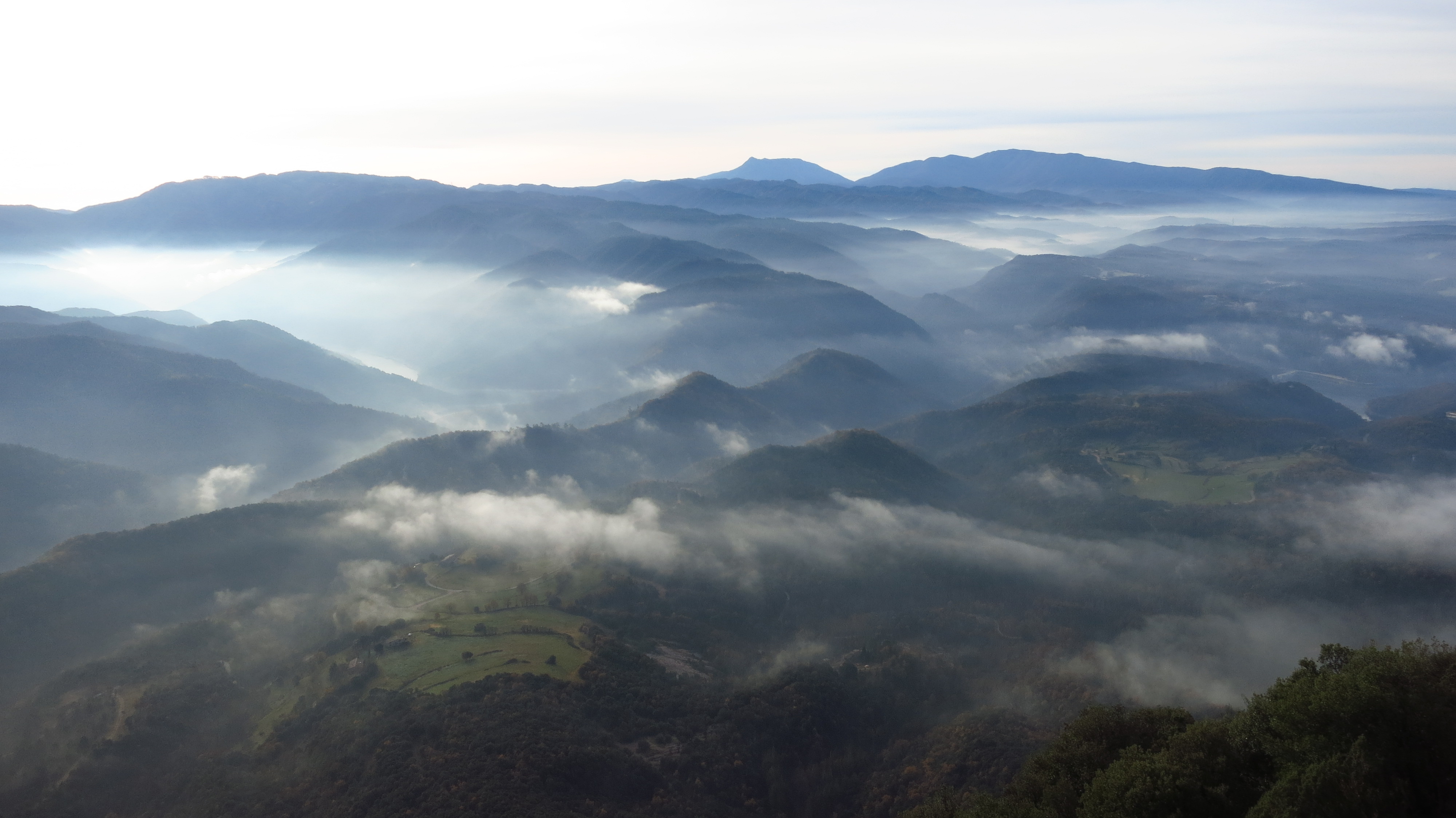
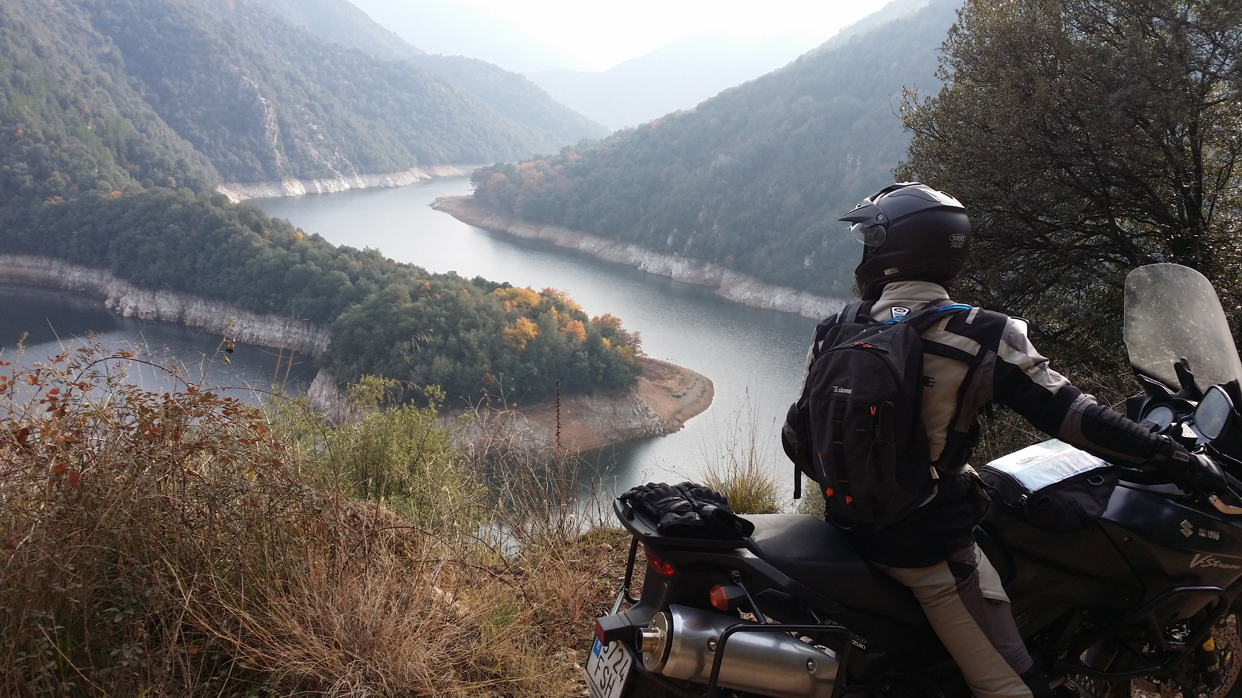
From here we start the most remote part of the route, a narrower and winding track through the forest, where we have a great time. In a tight downhill corner, next to an old electricity company hut and a fire extinction pond, the forest opens into a viewpoint perched over the Riera de Sorreig, with beautiful views.

The track keeps going down from here until a small reservoir and then goes up again, the forest thinning to reveal some farms here and there. While riding past one of them, on another tight downhill corner, my front wheel loses grip and I land on my right side. I must have been doing 30 or 40 km/h and, fortunately, have not hurt myself, but it has been without any warning at all. We lift the bike and check for damage; the upper crash bars have moved and made contact with the fairing, but a good pull between three of us bend them back in position, and there is nothing broken – indicator, mirror, brake lever… everything checks out. A closer look reveals that the brunt of the impact went to the lower crash bars, then the upper ones, the hand guards and the passenger footpeg. Crash bars are a good thing to have.

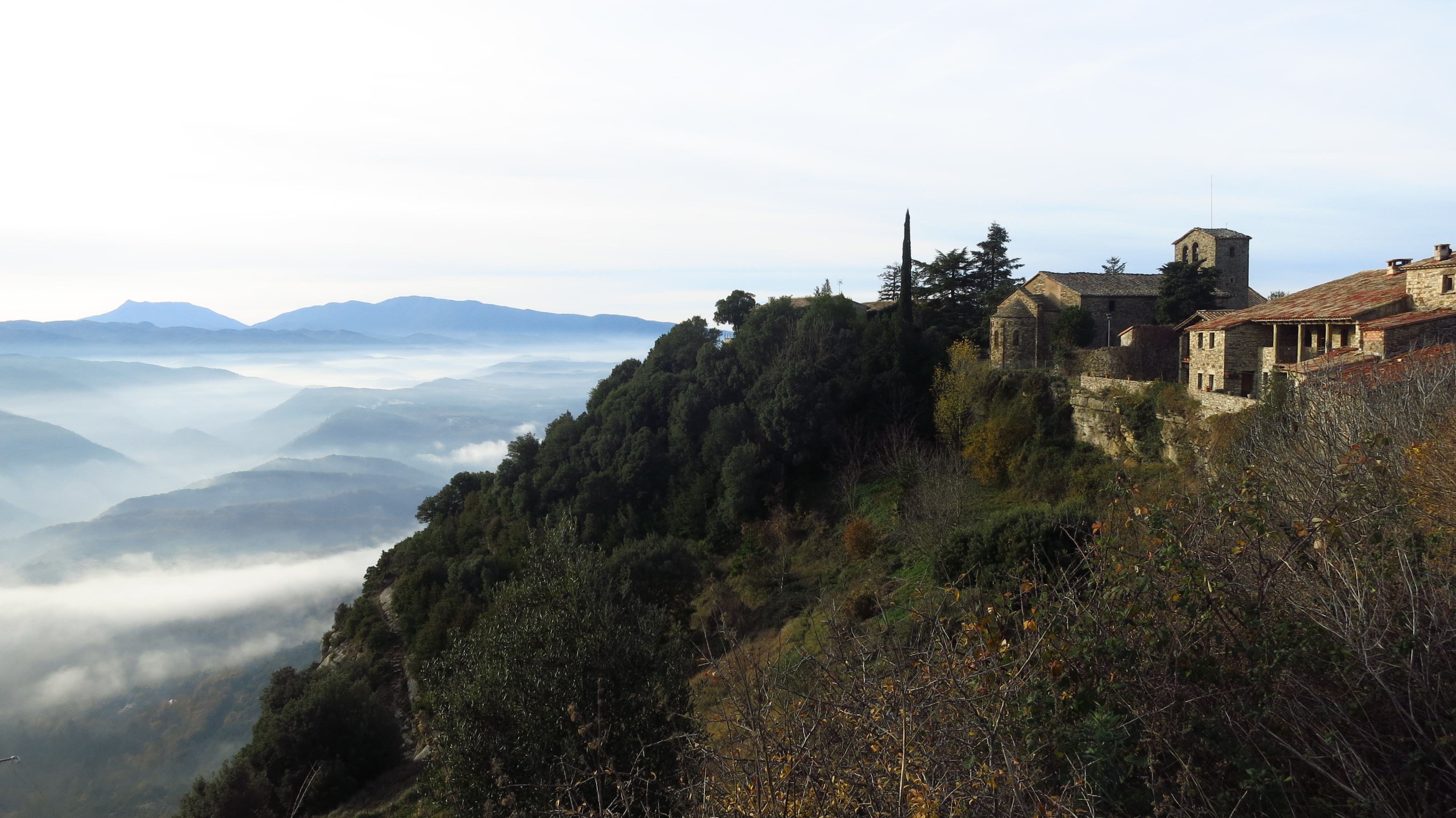
The track goes on, nice and level, until reaching Sant Boi del Lluçanès, where we ride tarmac for a very short while in the BV-4608 before turning left into the forest again. A few hundred meters in, another track starts to the right, going up to the Sant Salvador de Bellver monastery.

img-20160918-wa0025

The detour is worth taking, the views from the monastery are stunning, in a clear day like today one can see very far.

img-20160918-wa0028

We spend a while enjoying the views, chatting and joking, until we realise that right behind us the monks are in the church, sitting in a circle and meditating, so we decided to move on and not spoil their karma.

img-20160918-wa0030

After riding back down to the main track we pursue the route, which describes a long curve around the hill where the monastery was until we pass below it on the north face and the track starts losing altitude in one of the best sections of the morning. The confidence I had lost in the front tire is slowly coming back, and I increase the pace and enjoy this last bit before Orís, where the route ends.

Map

ruta-1

From here, the C-17 leads back home to Barcelona, but Ricard suggests a nice place to have lunch and make the route a bit longer, this time on tarmac. We ride up the C-17 to Sant Quirze de Besora, where we take a smaller road to Santa Maria de Besora and then an even smaller one, little more than a sealed track, until the Hostal La Serra de Llaers, a farmhouse turned restaurant in the middle of nowhere where we celebrate the end of the route with a huge salad and grilled sausages. The sealed track goes on past the restaurant, but to save ourselves the ride all the way up to the N-260a we take another track, the last bit offroad, that connects to the C-17 just south of Ripoll.

Map

ruta-2

What to see

This is an offroad route (aside from the short connecting tarmac sections), so the most interesting thing is the riding itself and the views. That said, it is worth taking a detour to visit the monastery and church of Sant Salvador de Bellver, whose origins date back to the year 1100. Abandoned during the 20th Century until it fell into disrepair, it has now been occupied by a community that have restored and enlarged the site. From atop the hill you can see great views including the Plana de Vic, Montseny and Montserrat mountains and even the Pyrenees.

Where to eat

At the beginning of the route, the road bar Olimpo is a classic meeting point for cyclists and bikers alike to have a good breakfast before setting off. At the end of the route by lunchtime, and if you are willing to ride a bit longer (30km), the food in Hostal de la Serra de Llaers is excellent.

Advertisement

Route – On/Off: Javalambre mountains II – Amanaderos, Fuente de la Miel, Alto de Barracas (95km)

The starting point of this route is, again, Ademuz. However, if you are coming from the Cuenca province it can be started from the village of Torrebaja, and from Teruel it can be started in Villel, both on the N-330 road.

From Ademuz, I take the N-330 heading towards Teruel. A good road if you are heading south, wide and with good tarmac, but heading north it quickly becomes a narrow country road that should be classed as a regional or even local road instead of a main route connecting Alicante with the French border. The 40km between Ademuz and Teruel are a bottleneck that sees heavy traffic of articulated trucks all year round, but environmental concerns about the Turia valley and, more importantly, the fact that this sparsely populated region has very little political weight have kept a better road from being built for decades.

Halfway to Teruel I reach the village of Villel, where an even narrower road with worse tarmac leads to Camarena de la Sierra and the ski slopes of Javalambre. On the way there there are two more small villages and, just before reaching Camarena, the road goes through a narrow gorge where I find a small picnic area and a fountain with cool mountain water pouring out of a lot of taps. After a short stop I reach Camarena, where I leave the main road right after entering the village and take the TE-34 that goes to the lower car park in the ski slopes.

Shortly after leaving the village, a sealed track starts to the right of the road and follows the Camarena river until reaching another picnic area. From this point, the track starts gaining altitude and becomes a dirt track after a couple of kilometres, but it is still good enough to allow the passage of regular cars without problems.

This track ends in the Matahombres fountain, a picnic area with barbecues, a fountain and a pond, a nice spot, but usually rather crowded, particularly in summer, due both to the ease of access in all kinds of vehicles, as I said before, and to the natural beauty of the place, even though the use of the barbecues is forbidden in the hottest months.

img_1420

img_1422

The circular route continues past the picnic area, but having reached this point it is worth taking a detour to the right and follow the ravine to visit the Amanaderos and the Yeguas waterfall. The surface on this track is a bit more broken, and even though it is not difficult to ride on, I would not take a family car on it. If the weather is dry there are no problems, but if it has been raining hard the usually dry ravine might carry water and complicate the crossing of a couple of spots.

Shortly before reaching the end of the track, a road sign of the same kind used at the entrance of towns and villages informs me that I am in the Amanaderos. I park the bike as close as I can to the edge of the track to visit this part of the ravine, where water springs up suddenly from behind the rocks and quickly becomes a steady flow that a few hundred meters down the valley becomes the Yeguas waterfall.

img_1425

After crossing the river, this time with water flowing across the track, I reach a point where the track widens and is possible to park. Beyond this parking area I can see some wood fences that prevent the oblivious tourist from a serious fall down the Yeguas waterfall, the first of a series of waterfalls until the river reaches the Montereta mill, where the valley opens into an area of orchards belonging to the village of Riodeva. It is a very nice trek on foot, but if there is not another vehicle waiting at the end to take you back to the starting point you’ll need to walk six kilometres back up the river to the Yeguas waterfall.

After admiring the waterfall from below, where it forms a pool where you can swim if you are brave enough to dip into the chilly water, I walk back to the motorbike and ride the track back up to the picnic area to continue with the route.

The track gains some altitude from here on and crosses forests of pine trees, still with no difficulty if it is dry. Shortly after, I reach Fuente de la Miel, where there is another picnic area, this one abandoned.

From this point, the track takes me up the mountains until reaching a plain, Alto de Barracas, where it splits in two – both tracks lead to the village of La Puebla de San Miguel, the one on the left directly, the one on the right through Calderón peak and Vicente Tortajada pine, a centenary pine tree in a flora microreserve. I take the route to the right, and after making my way through a couple of tight downhill corners that the recent rain have made a bit tricky, the track goes round the south side of Calderón peak, the highest point of the region, and reaches another crossroads. To the right it goes back to Alto de Barracas round the north side of the peak, and to the right it goes past Gavilán peak, this one accessible by motorbike and 4×4, since there is a firefighting service surveillance tower at the top.

Past this crossroads the road goes down the mountain fast, with some of the steepest segments paved in concrete, until reaching the last crossroads of the route.

The plan was to head back to the road from here, as I am close to La Puebla de San Miguel, only one kilometre and a little down the valley, from where the road back to Ademuz through a couple of hamlets begins, but I see a sign that tells me that the track to the right goes to Mas del Olmo, the first of those two helmets.  Wanting to stay off road for a bit more, I choose this option.

This last segment has no difficulties either, it is a nice track that winds its way through terraces of almond trees cut into the mountain, trying to steal some lands for crops from the jagged mountains, a good reminder of how hard life must have been for our grandparents in this area.

Once I reach Mas del Olmo the only thing left to do is follow the tarmac road back to Ademuz, my starting point.

Map

ruta-javalambre-ii

What to see

Ademuz – With a little over 1,000 inhabitants, this town is the capital of the enclave, built on the mountainside with a maze of narrow streets that confirm the Arab influence that its name hints to. At the top of the mountain stand the ruins of a castle, an old arab fortress called Al-Damus. From the entrance of the town a dirt track goes up the Pico Castro, a peak with excellent views over the town and its surroundings, including the river Turia. The shrine of Nuestra Señora de la Huerta, from the XIV century, is also worth a visit.

The Amanaderos – This is the point where the Rambla de los Amanaderos, the stream that later becomes the Ríodeva river, springs up. In this apparently dry part of the ravine water springs up from several places between the boulders. There is no place to park, but motorbike might be left as close to the edge of the track as possible to allow the passage of other vehicles. Alternatively, this spot can be reached on foot from the car park in the Yeguas waterfall, a short distance down the ravine.

Yeguas waterfall and Ríodeva river trek – This waterfall is the first of the several that, together with a few natural pools, make up an interesting trek down the river until reaching the Montereta mill. If you have another vehicle waiting for you in Ríodeva it is possible to do the whole trek and enjoy the views of the waterfalls and the valley, if not, you’ll have to walk 6km back up from the mill. In any case, it is worth walking the first part to see the waterfalls.

Puebla de San Miguel natural park – Part of the route goes through this park. Here you can find Calderón peak, the highest peak in the Comunidad Valenciana with a height of 1,837 metres. Reaching the top has zero difficulty, it is just a leisurely walk from Alto de Barracas. The park also has several flora microreserves, all of them signposted and with information panels.

Shrine of La Puebla de San Miguel – If we take the route down to this village, the track joins the main road just past this good example of the typical shrine architecture in the region, with a porch over the front entrance.

Where to eat

Casa Domingo, the main hotel in Ademuz, has bar and restaurant service. In Camarena de la Sierra, just after turning into the camino del Balneario, the road that takes us to the start of the off road part of the route, there is the Hotel Esmeralada.

Route – On/Off: Cingles de Tavertet, Sau i Susqueda, Les Guilleries, Montseny (152km)

The Route

It’s ten to eight on a frosty Saturday morning when I meet my riding buddy for the day at an industrial state run-down petrol station infamous for being the place that witnessed the end of a 492-day long kidnapping in 1994. There is not a single person in sight except for the lone silhouette of my friend and his Ténéré standing in the morning mist.

We are still 50km away from the starting point of the route, half an hour of intense cold and thick fog that makes the road ahead look like a scene straight out of Fargo.

20151212_085028

The route we have planned for the day starts just off exit 183 on the C-25 road that connects Cervera and Girona. Despite having heated grips on both motorbikes, our fingertips are painfully cold by the time we turn off the motorway, the hand guards being very good at protecting the brake and clutch levers in case of a fall but not so good at aerodynamic protection for our hands.

On the C-153 road, we ride across Roda de Ter as the sun struggles to break through the mist, making it hard to get any decent pictures of the old Roman bridge that crosses the river Ter. A few kilometres later, the road starts climbing up the hills through grazing fields, a much more interesting ride after the relatively long motorway slog to get here, but we have to take it easy, as the tarmac is wet and slippery.

In the nearby village of l’Esquirol we turn right off the main road and take one of my all-time favourite roads – the BV-5207 leading to Tavertet. Even though the road ends there, in good weather there are quite a lot of tourists driving it to get to the quaint village perched atop the cliffs overlooking the Ter valley and the Guilleries mountains beyond, but this early on a winter morning the road is ours. It is half past nine now, we have gained enough height to leave the morning mist behind and the sun shines gloriously over the stunning landscape.

IMG_6504

A few corners before Tavertet we stop at a viewpoint overlooking a valley where a wild boar hunt is taking place and meet an old man who is following it on his walkie-talkie.

20151212_092956

He tells us that there each year there are more and more wild boars in the area and they have to organize these hunting parties to keep the population under control. His knees are too old for him to join them as he did when he was younger, but he still takes pleasure in checking the progress of the hunting. He points at an orange spot in the thick forest below us – a hunter in a high-visibility vest, and a few seconds later we hear some shots that resonate against the cliffs and sounds like a hundred shotguns being fired at once.

IMG_6500

At the entrance of Tavertet we find a boom gate partially blocking the road. It is there only to prevent the numerous tourists who drive up here to enjoy a meal at one of the restaurants from parking inside the tiny village, you can drive around them and keep going to the east side, where a small sealed forest road keeps climbing along the edge of the cliffs to a plain from which the Pyrenees are visible in the distance. The views from up here are magnificent, in a few hundred meters of road one can enjoy an almost 360º panorama of the main mountains in Catalonia – Pedraforca, Guilleries, Montseny, Pyrenees…

IMG_6509

From there the road descends through a beech forest with the ground covered in a carpet of reddish brown fallen leaves to end back in the C-153 road leading to our next waypoint – Rupit.

IMG_6511

There is a dirt road from Rupit to the Sau reservoir along the foot of Tavertet cliffs. I have used that road twice before – on a mountain bike trip when I was twelve and driving a Fiat Punto when I was at university with my girlfriend at the time. I remembered a dirt road in good condition, and to my surprise we find that it has been paved all the way. It is a very nice ride through forest and across grazing fields, with views to the rocky cliffs on top of which we were less than an hour ago.

IMG_6512

Once at the bottom, we take a short detour from our main route to ride to the shore of the reservoir and have a snack with a view of the church spire of the village of Sau, which is all that remains visible after the dam was built. With full bellies but hands still very cold, we ride the few kilometers left to the dam itself to explore the only part of the route I have never ridden before.

20151212_105722

Looking at maps and satellite images, there seemed to be a road along the south shore of the Susqueda reservoir leading to its dam and then to the C-63 road, but I was not sure it was accessible. It could be a service road for the reservoir or it could be a forest road in bad condition, and I am not particularly keen to venture into difficult terrain as my bike is shod with (worn out) road tires. We cross the dam to where there seems to be a road, but it is blocked and it looks it has been so for a long time. Falling rocks and landslides. We cross back to the northern shore and ride down another road that seems to lead to the power station at the bottom of the dam. It does. It ends in front of a gate, but on the way up we find a dirt road that seems to go further down. It looks steep, at least the first meters, but I notice regular car tracks on the sand, so we think “how hard can it be?” and ride on.

IMG_6517

The road seems to be in good condition and a bridge at the bottom of the gorge takes us to the southern bank of the river Ter. From there, we follow a narrow dirt road that puts my poor bike to the test. Rocks, sand, mud and leaves make it clear that road tires, short suspension travel, and hard springs are definitely not the best combination here. God, I miss the Super Ténéré…

20151212_114022

IMG_6520

An hour later the Susqueda dam comes into view out of the last corner. We are sweaty and my wrists and back hurt from the bad position standing on the footpegs, but I also have a big smile on my face. We have made it.

IMG_6523

A good road leads to the C-63, which we take for a short while before reaching Anglès and turning into the GI-542 for the last part of our route. This road winds its way up the Guilleries mountains past the village of Osor and to Sant Hilari de Sacalm, famous for its many springs that produce much of the bottled water sold in the country. From there we are going to take a smaller road to the Montseny mountains. This one is a bit more difficult to find at first, as it is not indicated anywhere, but then we find out that it is as easy as to follow the signs pointing to “Fontvella”, the main bottling plant in the area, from where the road starts. It is well past midday now and the road is completely dry, so we can ride faster and enjoy a wonderful road – perfect tarmac, no traffic, great views.

IMG_6526

Shortly after we cross the C-25 again, and take the GI-543 and BV-5303 along the northern edge of the Montseny natural park to end our route back on the C-17 main road to Barcelona.

Map

Mapa

What to see

Roda de Ter – Old Bridge: dating back from Roman times, it was part of the Strata Franciscana, the road that led to France.

Tavertet – A quaint, tiny cluster of stone houses built on the edge of the cliffs of the same name. Well worth a visit and a hike in the surrounding area, with breathtaking views of the whole region at your feet.

Rupit – A XII Century village of narrow steep cobbled streets, with a hanging wooden bridge and the remains of a medieval castle.

Pantà de Sau – The spire of the bell tower is all that remains visible of the village of Sant Romà de Sau, which was submerged after the construction of the dam in 1962. When the water level is low enough during summer draughts the church emerges an can be accessed on foot from the shore.

Where to eat

Once you reach Seva, practically at the end of the route, a seven-kilometre detour up the BV-5301 takes you to two excellent restaurants that serve traditional home-made Catalan food in the hamlet of El Brull – Can Pasqual and Castell del Brull.