
Day 4 – Thursday 3rd August – Séez to Briançon (227km)
Taking things easier is definitely worth it. Today I rode the second half of the route to Briançon, which I wanted to do in one day. Is it doable? Sure. Is it worth it? Definitely not. You might easily cover the distance in one day, particularly if you want to enjoy a good blast up the cols, but then there is no time to stop at the top of each one, take pictures, enjoy the view, chat to other bikers, have a drink, check the map, stretch your legs and rest for a while…
So take it easy I did. Even though I only covered 227km today, I got to the campsite in Briançon at about the same time as the previous days but a lot more relaxed, having enjoyed each and every one of the cols on my route today.
I set off an hour later than usual because I wanted the tent to dry up a bit – I hate to put it away damp – and used that time to enjoy a chat with a German biker who had camped next to me. We talked about the heat, riding routes in the region, motorbikes and so on, and he recommended a good campsite in Briançon.
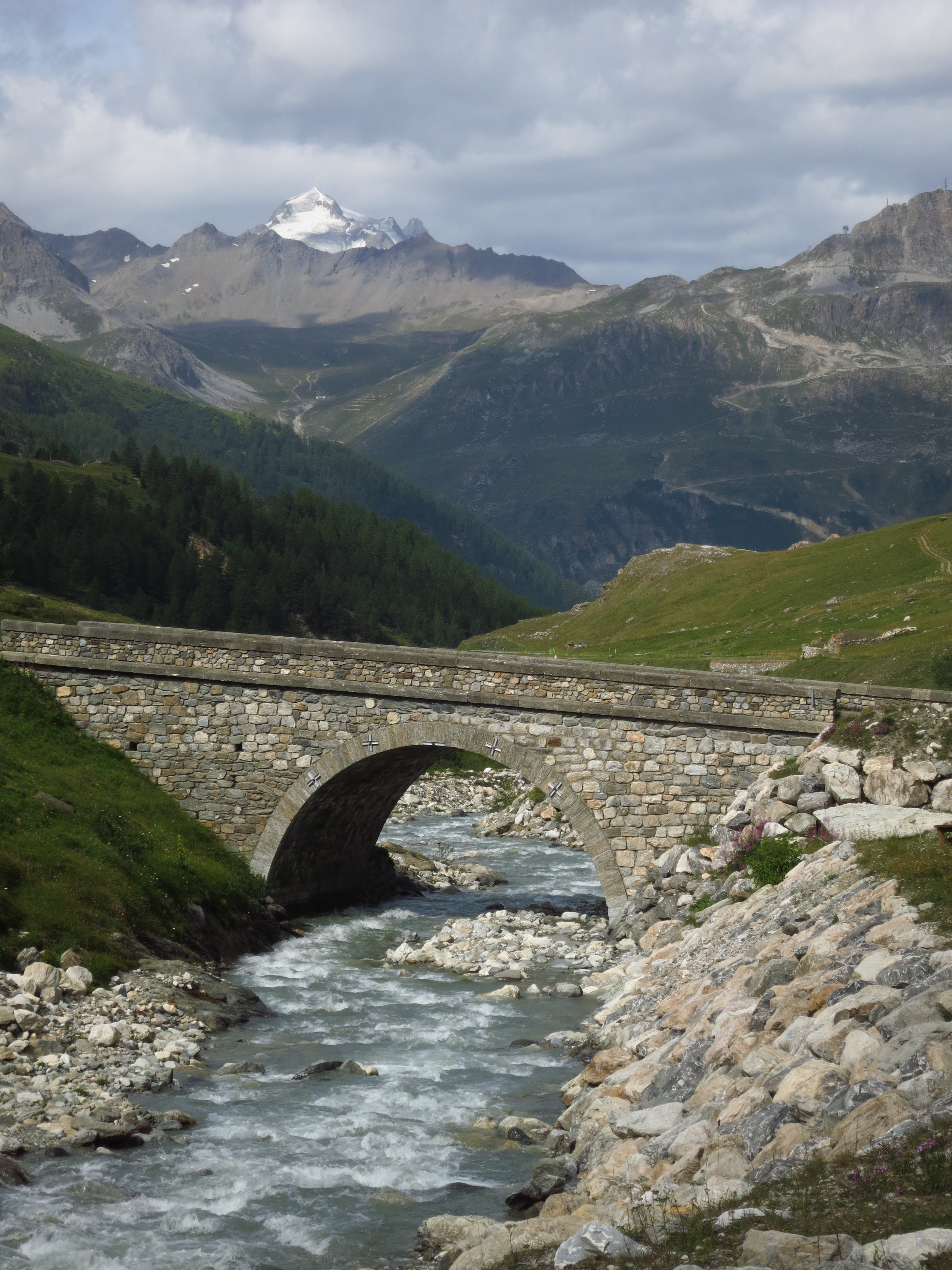
Out of Séez, the D902 was full of traffic. I almost immediately run into a long, slow moving line of cars, vans, lorries, etc. which I started to overtake one by one as soon as there was a bit of straight road. It turned out that the reason for the hold-up was heavy lorry carrying an excavator – once past it, the road was mine and I enjoyed it to the fullest… until I heard the GoPro give its dying beeps, signaling the moment to replace the battery. ‘Not now!’ I thought. The ascent to Col d’Iseran, the highest in the route, was about to begin and I did not want the lorry and the dozen cars behind it to pass me. I pushed harder, hoping to open a gap big enough to be able to do a quick pit stop and keep my rivals behind me, F1 style. I pulled over when I reached Lac du Chevril, but then the views were so nice that I had to take a few pictures, completely neutralizing the advantage I had.
 Sure enough, the lorry emerged from a tunnel down the road, it’s engine grumbling with the effort of carrying so much metal up the mountain and, to my surprise, it stopped where I was. He was letting cars pass, I imagined, a courtesy I had seen other trucks show towards the rest of road users, and a gesture many motorhome drivers should learn a lesson from. For the first time in the journey, it was getting quite cold, especially with all the vents in the suit open, so seeing that it would not get any warmer further up, I decided to take the chance and set about securing fasteners and closing zips. I was about to finish when I heard the air brakes of the lorry hiss, I turned around and saw it jerk into motion again and pull out in front of me while I gaped at it like an idiot with my jacket half done. Damn! The good news is that once I reached Val d’Isère, the famous ski resort, most of the traffic, including the lorry, disappeared, leaving the road clear for the guys in two wheels.
Col de l’Iseran, at 2,764m (the sign there reads 2,770m), is the highest paved pass in the Alps and offers impressive views over the Vanoise national park.
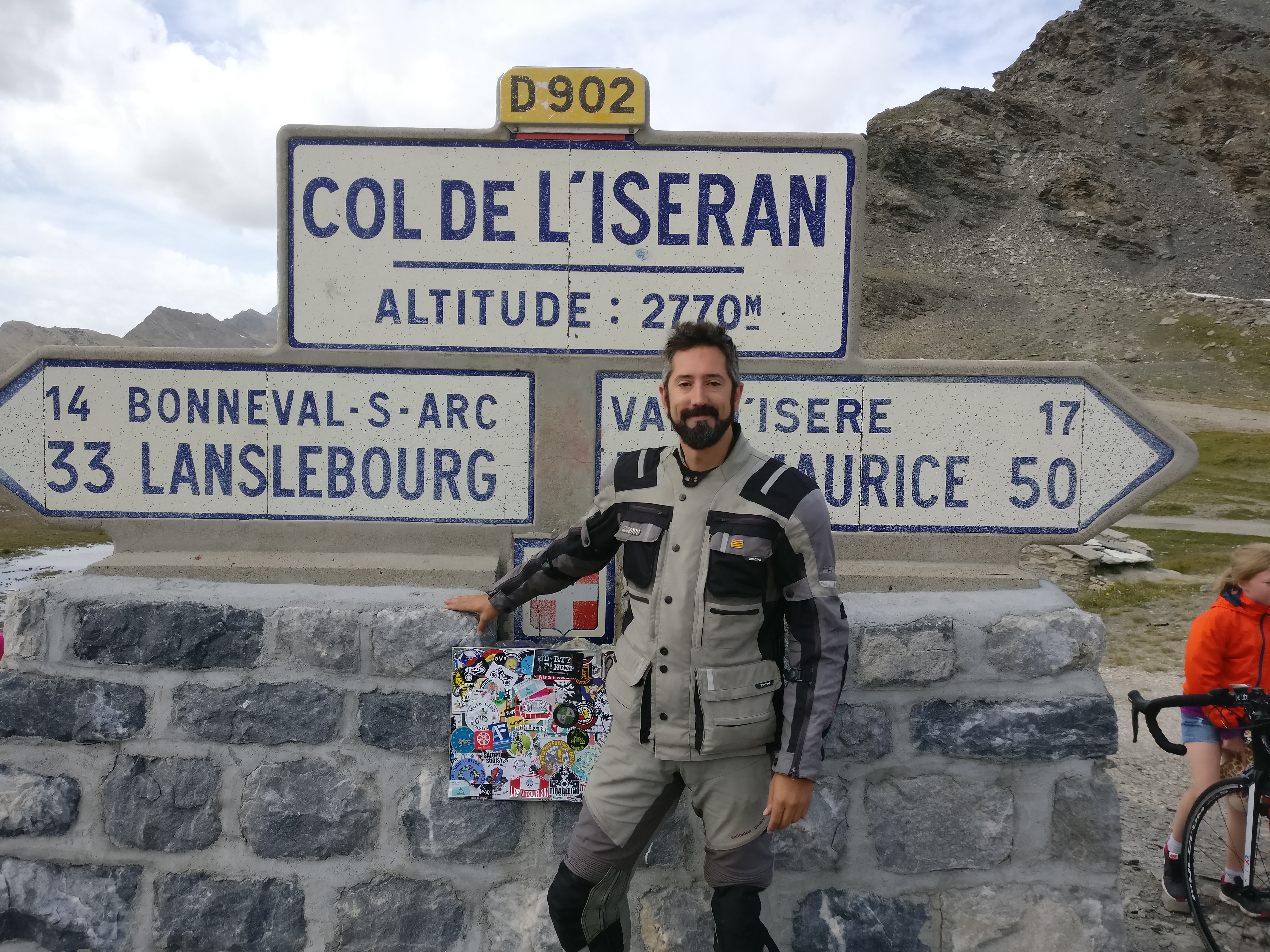
A lot of bikers had congregated there, but among all the machinery what drew my attention was a couple of 125cc motorbikes who had bravely made it all the way to the top, as well as a couple on a BMW who were travelling with a dog! Sporting a pair of Doggles, of course.

On the way down the road crosses the village of Bonneval-sur-Arc, a quaint cluster of typical alpine wooden houses that is as representative of the area architecture as it gets. Past the village the valley opens wide and the road travels through pine forests, gently losing altitude. So gently, in fact, that I almost missed the next col, one I was curious about. According to the map, it was called Col de la Madeleine, but I had already crossed a col with that name two days ago. Being a complete ignorant in Tour de France matters, I did not know which was the famous one and I wanted to compare them. This one was nothing more than a slight bump at the end of the valley before the road went down to Lanslevillard, a rather flat affair with just a road sign indicating its existence. I guess the other one is the famous one, then.

Past Lanslevillard I took a small detour to the right. I had time and there was a col on one of the alternatives to the main route that I wanted to see, Col du Mont St-Cenis. I don’t know why I had decided that it was worth a detour, I did not know anything about it, maybe it was just instinct but it is definitely worth the time. The road was nice and empty, gaining altitude through a forest with some skiing slopes in it, and the col had beautiful views over the valley I had just left below but the best part was beyond the col – there is a beautiful lake with several forts along its shores. I decided to ride down to the dam and have lunch near some ruins overlooking the water, and that was how I ended up doing some unexpected bit of offroading.

A dirt track turned off the road above the ruins and I could see cars down by the water, so I figured it would be easy to get there and turned into it. The first few hundred meters were fine, but then I found a section with some ruts – that would not have normally been a problem, but I was going down and I had a fully loaded bike, so I was not entirely comfortable. However, there was no space to turn around, so down I went. To my relief, it was only a short bit, and then the track became easy again by the ruins. I stopped and had lunch enjoying the view and congratulating myself for my offroad prowess.

I took the same way back to the main road, which was rather unremarkable for a while. I stopped for supplies in Modane (cheese and wine, bien sûr!) and then headed for the next two cols of the day – Col du Télegraphe and one called simpy ‘Le Col’.
Feeling a bit drowsy after lunch, I decided to take a break in the bar at the top of Col du Télegraphe and order a coke. While a was there, three rather big old guys in Suzuki Intruders 250 pulled up, sat at the bar and ordered three beers. Way to go! I left and reached the town of Valloire without seeing the oddly named ‘Le Col’.
Two more passes to go only before the end of the day – Col du Galibier and Col du Lauteret. The ride up the first one was serious stuff – very tight hairpins, steep sections and sharp drops with no protection whatsoever but you know, no risk no rewards, and this was my favourite so far. It may not be the tallest, but it only lags about 100m behind Col de l’Iseran and has amazing views to both sides of the col, with a last section so steep that there is a tunnel to bypass it a few hundred meters below the top. Not that the tunnel helps much, mind you. With heavy wooden doors at its entrance, it is so narrow it only has one lane so traffic is regulated by a set of traffic lights. Oh, and caravans, vehicles taller than 4m and/or heavier than 19 tonnes cannot use it, meaning they have to negotiate the heart stopping last section at the top. A legendary pass.

The roads then leads down to Col du Lauteret, which I had crossed in 2013 on my way to conquer (or fail to conquer) the road to Mongolia. It was the only pass I crossed on my way east and I found it amazing. Coming down from the Galibier, however, it was rather underwhelming.

All that was left to do for the day was coast down the main road to Briançon and find the campsite that Harald, the German biker I had met in Séez, had recommended. Oh, and find a workshop where I could borrow some pliers. My stove was running out of fuel and with all the going up and down high passes the pressure differential had made it completely impossible to unscrew the filler cap.
I stopped at a petrol station in La Salle-les-Alpes, filled the tank, squirted some petrol into a plastic bottle for the stove and went over to the garage next door to ask if I could use their pliers. Only when I was going back to the bike did I notice that the place looked familiar. I had stopped to fill up in this very same place in 2013!
The campsite was just outside Briançon, but I had to cross it first, and it was hell. Temperature was over 30ºC even at this height, and there was a never-ending traffic jam in the centre. The campsite was nice, though, and I put up my tent ready to spend more than one night in the same place since the beginning of my trip. The following day I was going to remove the panniers and head to some of the offroad trails I wanted to do.
Col counter:
14. Col de l’Iseran 2764m
15. Col de la Madeleine 1746m
16. Col du Mt-Cenis 2081m
17. Col du Télégraphe 1566m
18. Le Col 1530m
19. Col du Galibier 2642m
20. Col du Lautaret 2058m
