
Day 3 – Thursday 27th of August – Caen to Cherbourg-Octeville (206km)
The zombie was already in bed when I walked into the dorm at 10pm after dinner, and by 7 am the following morning he was still sleeping and it was still raining. By the time I came back from breakfast he had disappeared, though, but unfortunately the same could not be said about the rain.
If it did not stop soon, visiting all the D-day beaches was going to be tough… But up here there are two kinds of weather: rain and heavy rain, so I decided to set off anyway.
Heading out of Caen on the D514 the weather was only rainy, and in a few minutes I reached the first stop of the day – Sword beach. This was the easternmost of the five beaches where the allied army landed, the closest to Caen.

It was a bit of a disappointment, though. There is not much left of the landing there, most buildings and bunkers were heavily bombed and are gone today. I parked at the Sword Beach Landing Museum, but it did not open until 40 minutes later. The weather had changed to heavy rain and I did not want to wait out there, so I went on along the beach and stopped each time I found something to visit – first a memorial on a small mound from which I could take in the size of the beach. It was long, wide and flat, unlike the beaches leading up to rocky cliffs that are usually depicted in films.

The landings here were successful and with very little casualties, the advance of the allied troops only meeting resistance once they started to move inland.

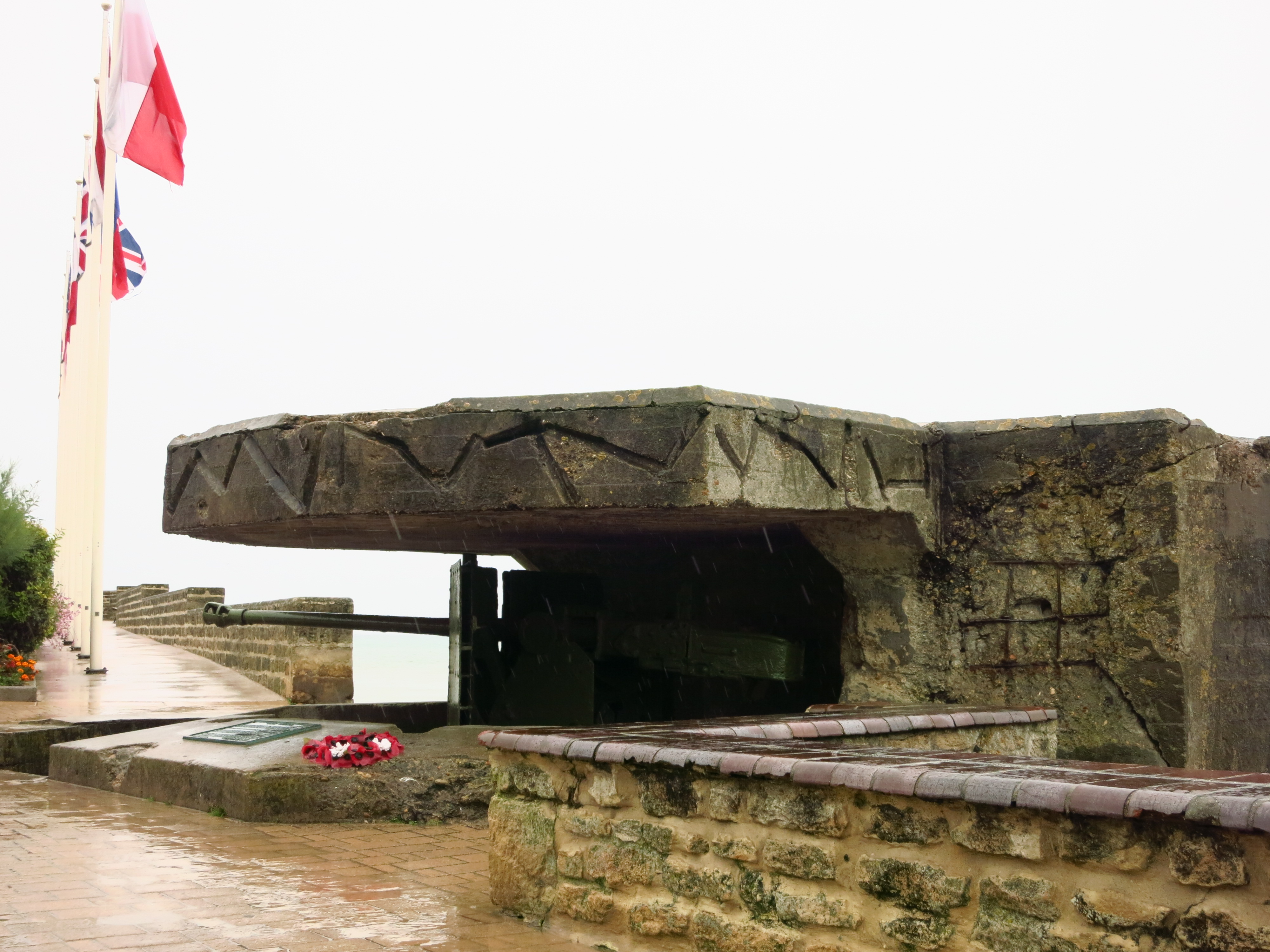
I also found a British Mk VII Cavalier tank by the side of the road and a bit further a piece of artillery that, curiously, pointed inland, or at least it seemed to. It was an anti-tank gun built that way to protect it from attack from the sea, and it could turn more than 180º to cover the beach in both directions.
Next stop was Courseulles-sur-Mer, at Juno beach. This beach was assigned to Canadians and the British, which is why there is a Canadian museum of the landings. Now, you might think that museums sound like a good thing to visit if it is raining outside, and you would be right, but that is if you travel by car. On the bike, keeping yourself dry is a process that involves several layers and they take time to put on and take off. Leaving them on means dripping water all over the museum and suffocating in the gear that keeps you warm on the road, taking them means either a strip tease show in the car park or taking the time to find a private place to do so, and it is laborious. Fine to do once, like for lunchtime, no so much when you stop to visit something every ten minutes, and because it keeps you dry, you might as well visit things outdoors. With that reasoning, and with the weather in very heavy rain mode, I visited the beach and the remains of some bunkers near the museum with even the helmet on. There was nobody else out there, luckily, as I looked like some kind of weird astronaut exploring a rainy planet Mars.

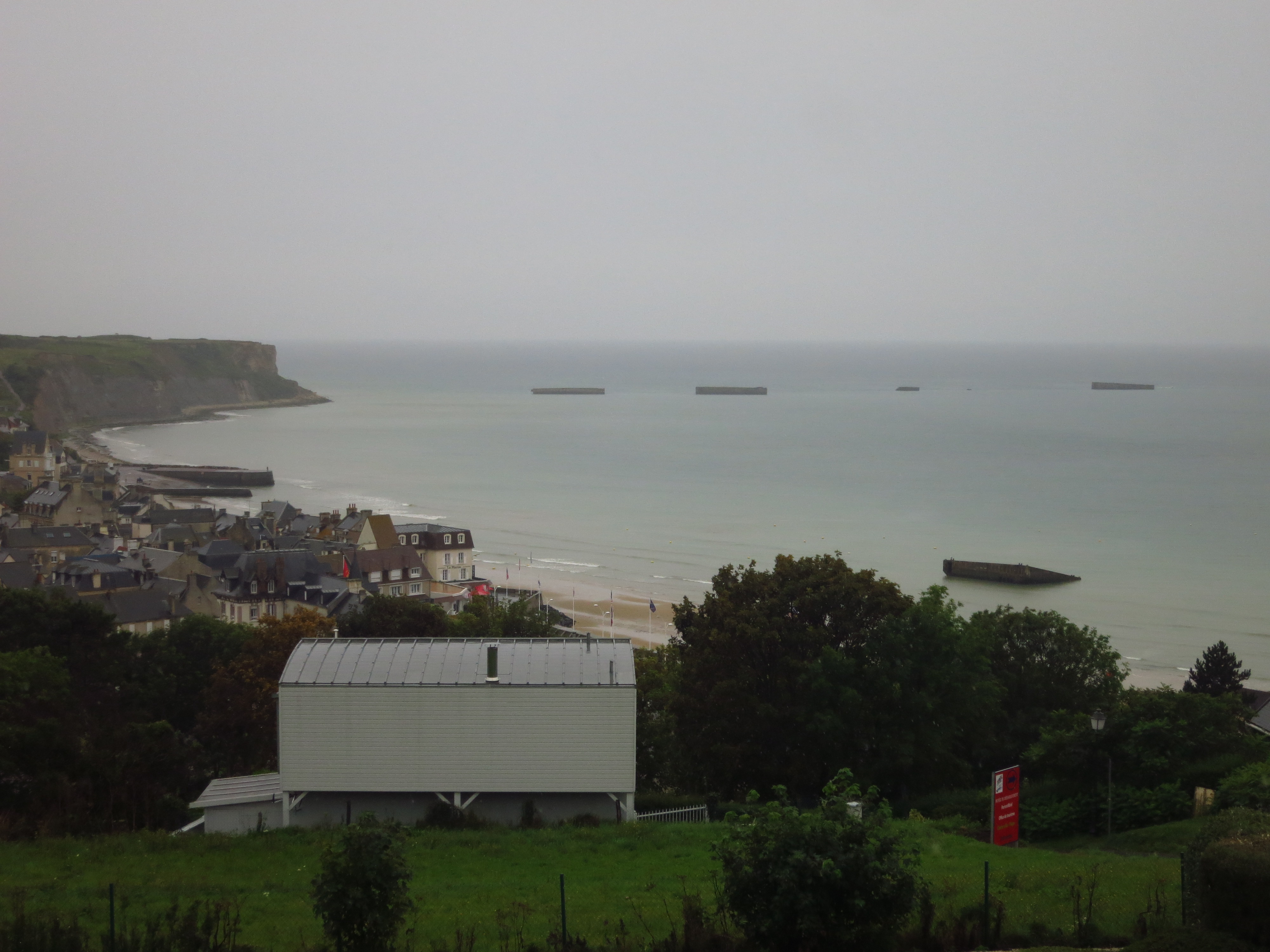
I was looking forward to the next stop – Arromanches. It was the site of Gold beach, where one of the most astounding feats of engineering in the war took place. The Mulberry Harbour.
The town is on a beach between two cliffs, and overlooking it there is the Arromanches 360ºCinema. Its car park offers a perfect viewpoint from which to see what is left of the structures that formed the harbour. The tide was high, so I could not see much. Some of the enormous concrete breakwaters that had been laid in a semi-circle to protect the harbour from the waves were still in place, as were a few concrete structures near the beach, but that was it.
Then I turned away from the beach to go to Bayeux, first city to be taken the day after the landings, and site of the largest of 16 Commonwealth cemeteries in Normandy. It was pouring down and the cemetery was far from the car park, so I did not visit it. After that, the weather seemed to have decided to give me a break for the most impressive sight of the day – Omaha beach.
The road at this point does not go right along the beach, for we are in the area where the infamous cliffs depicted in countless movies are, but there are numerous signs on the main road that point to different lanes leading down to the it. I turned off at the first one in Colleville-sur-Mer and rode down to find the section of the beach where the 1st Infantry Division, the Big Red One, had landed.

Omaha was assigned to the Americans, and they knew it was the hardest of the five beaches to take. It was heavily defended, surrounded by cliffs, and to the west there were the Pointe du Hoc fortifications, which could lay their fire over the beach. These men, together with the 29th Infantry Division in the western section of the beach, were the first wave of the attack on Omaha.
After a crossing in very rough seas that flooded the landing craft and sank 10 of them, they reached the beach and found it unexpectedly well defended. Fire from small arms, machine guns, mortars and artillery rained down on them from the high ground held by the Germans. A lot of them did not even reach the beach, their craft dropped them on sand banks and they had to cross almost 200 metres of sand and water, laden with weapons and equipment. Those who landed on either end of the beach got the worst part, being closer to the defences on the cliffs. The bombs dropped by the allied planes in the hours prior to the landing had fallen too far inland, leaving most of the German defences intact.
Right in the heels of the first wave of attack came the engineer corps to clear paths through the obstacles so that more infantry and artillery troops could land, but due to the chaos and the bad weather most of them did not land at their intended locations and had to do their job with little to no protection from infantry.
All in all, there were about 3,000 allied casualties that day.
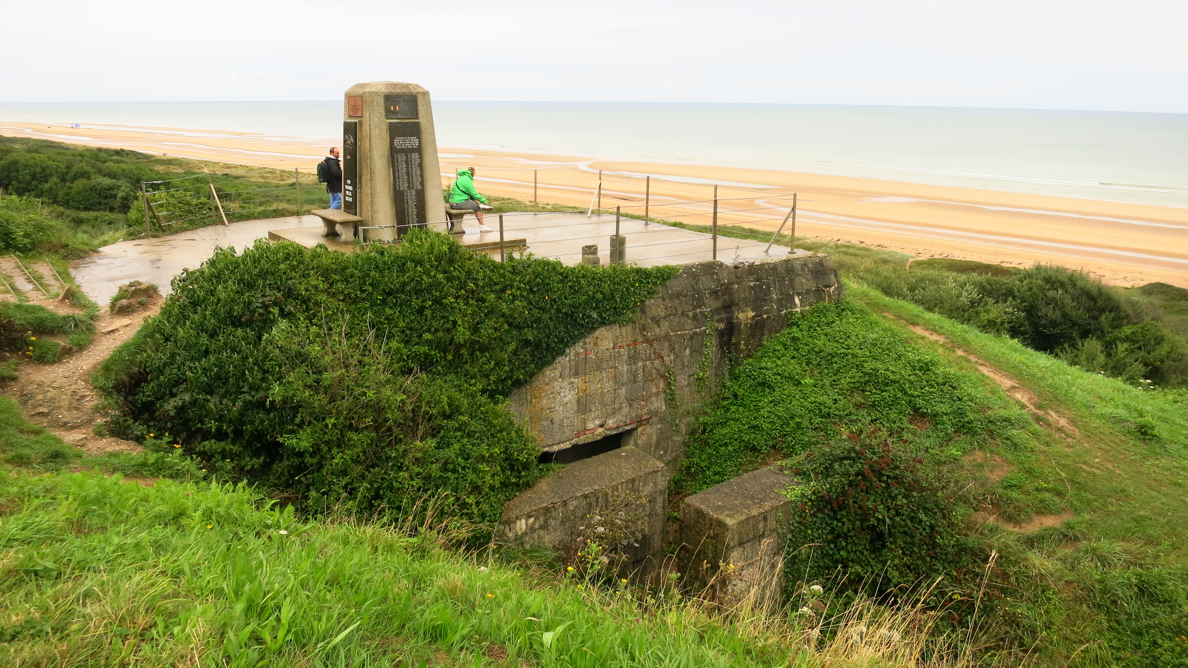
There is a memorial to the 1st Infantry Division here, at the site of the German strong point WN62, the most important of 15 strong points defending Omaha beach. Only part of it remains today, but seeing the size of the place and the armament it had, one cannot but marvel at the bravery of the men who took this site.
Up on the bluffs that overlook the beach and that were so hard to take, there is the Normandy American Cemetery. Row after row of the white crosses mark the graves of 9,387 men who lost their lives here.

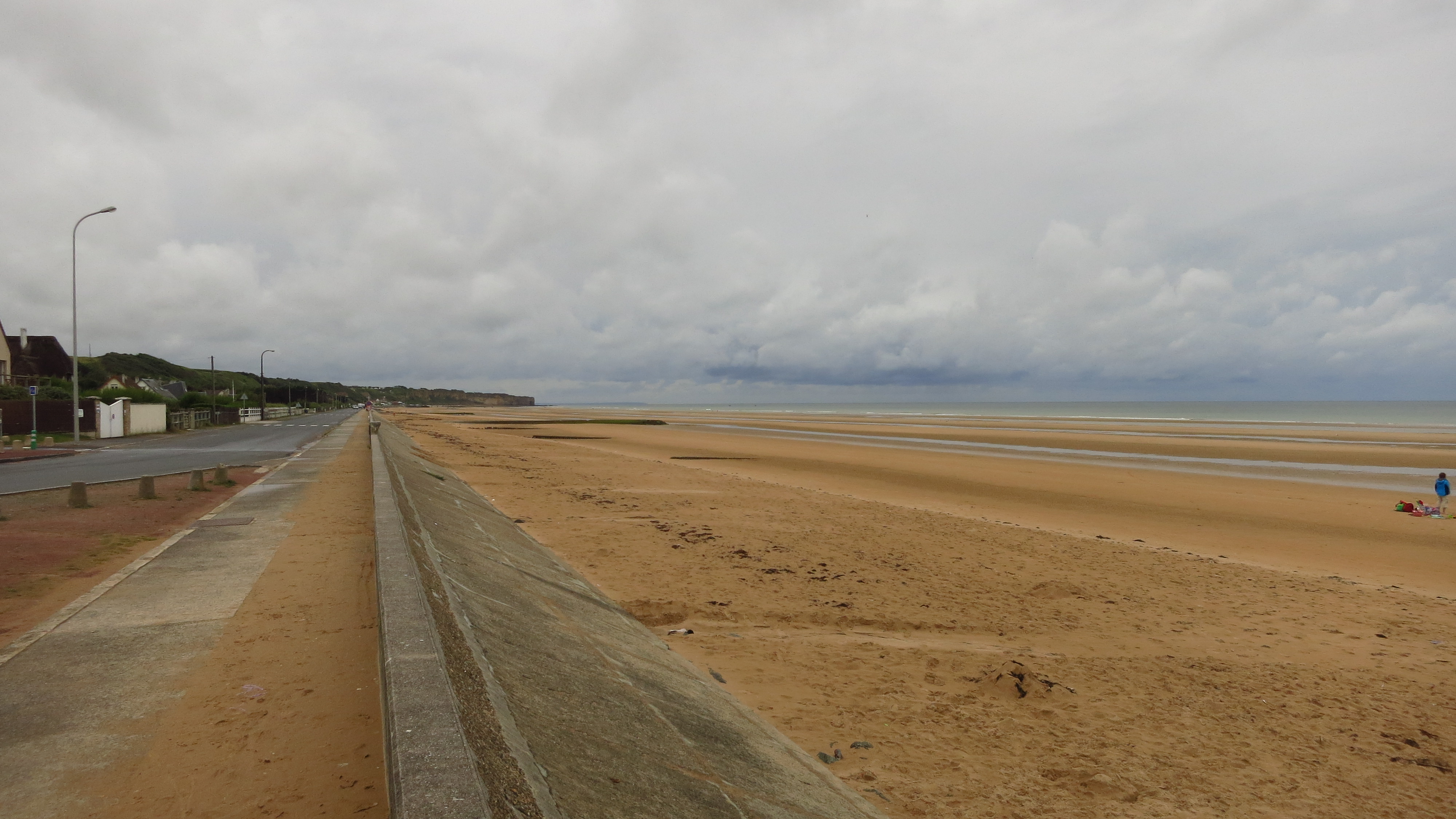
The rain finally stopped for good when I was at the Omaha Beach D-day Monument at Saint-Laurent-sur-Mer, which gave me some time to visit the monument and walk along the beach. At this poin it is wide at low tide and there are no cliffs, but there are still some hills and only one way out of it, through a valley that becomes narrower as it heads inland.
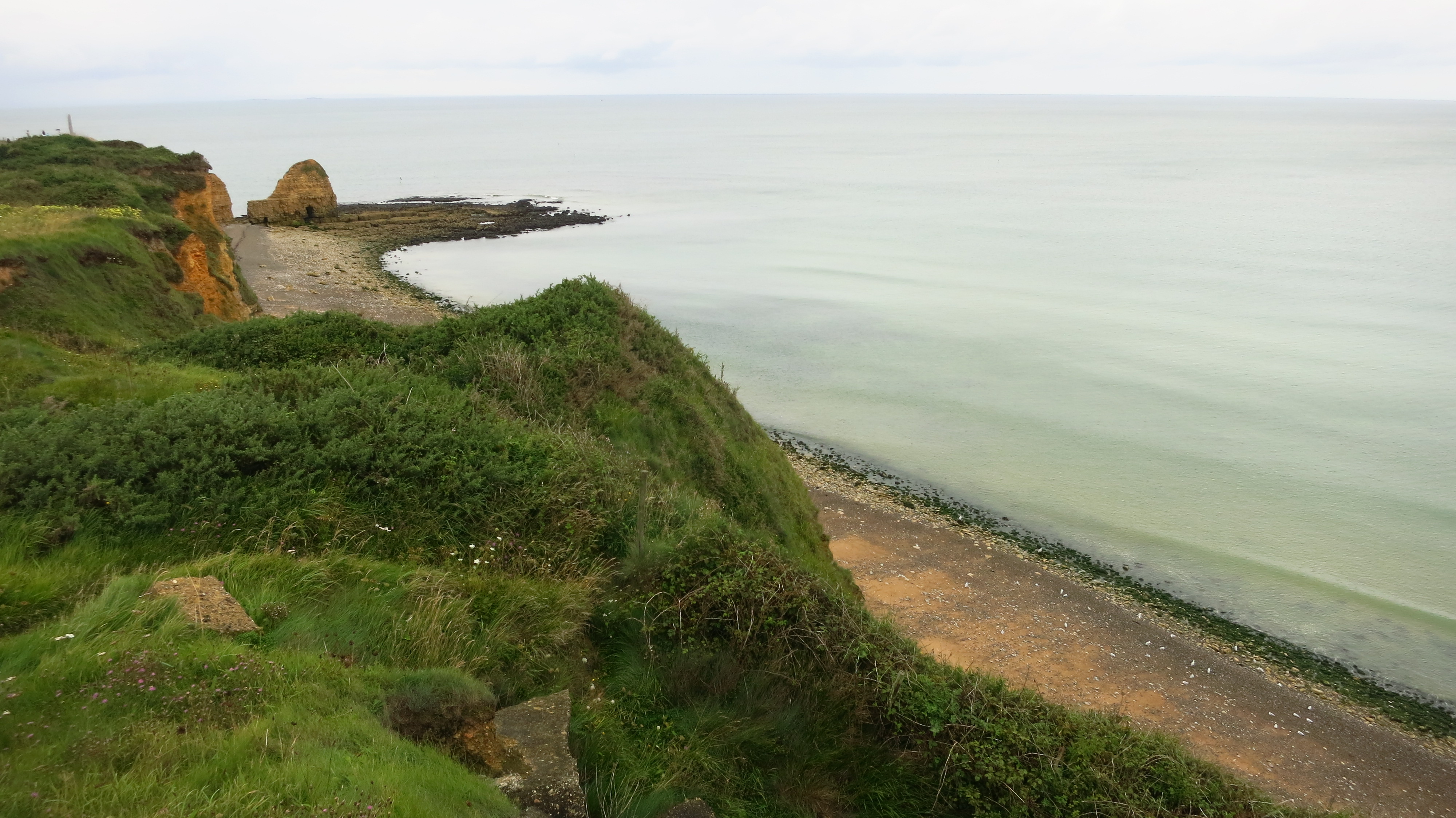
In addition, those who landed here were exposed to the artillery fire coming from the next site I was going to visit, and the scene of one of the bloodiest battles of the day – Pointe du Hoc.

Point du Hoc is a promontory between Omaha beach, to the east, and Utah beach to the west. With a 30-metre cliff, it is the highest point between the beaches, and being such a critical position, the Germans had fortified it as part of the Atlantic Wall. It posed a great threat to the allies operation, so a special plan was devised to take it. Three companies of Rangers would land at the foot of the cliff before the main landings and climb it using ropes and ladders to fight the Germans at the top and gain control of the area.
As with other landings that day, the bad weather badly decimated the 12 landing craft and four amphibious trucks heading for the attack – two boats and two trucks sank. The troops had rocket launchers with which to fire hooks onto the wall of the cliff and attach climbing ropes, but the ropes had been soaked during the crossing and were heavy to reach the wall. In addition, the 30-metre ladders they carried turned out to be too short to reach the top of the cliff.
The plan was for the Rangers to signal for reinforcements once they had reached the German positions at the top. If the signal did not come, the eight Ranger companies that were supposed to help them were to turn to the beach and help the landing there. Because they took so long to climb the cliffs, by the time the signal was sent the rest of Rangers were already on the beach, thinking they had failed, which meant they were left on their own to take the guns positions and clear the ground inland.
When they reached the fortifications they found that the guns had been removed to protect them from allied bombings, it turned out that the artillery fire raining down on the beaches was coming from the Maisy battery, further west. Two patrols found the guns some distance inland, camouflaged in the bushes and ready to fire, and destroyed them. But despite having taken the fortification, the worst was still to come.

Of more than 225 men in the attack, only 90 were left able to combat effectively. Without reinforcements nor radio communication, they had to fight against constant German counter-attacks trying to regain such a critical position. Only after two days of fighting in terrible conditions were they relieved when tanks and infantry finally linked with them from the beach.

Although partially destroyed, most of those fortifications are still at Point du Hoc today. It is a maze of bunkers, casemates and gun pits. It originally consisted of six 155 mm French guns from WWI in open pits, but realising the importance of the position in the case of an attack by sea, the Germans had set out to build six casemates. They used French forced labour, who worked as slowly as possible to try and sabotage the construction, and at the time of the landings, two were still unfinished. That, and the fact that the guns had been withdrawn inland to protect them from air raids, prevented the landings at Omaha and Utah beach from being even more deadly.
With the rain gone but the skies still grey, I reached the last of the five beaches – Utah beach. There was a memorial, a museum, a Sherman tank and a replica of one of the landing crafts used in D-day.


It was late, my boots and gloves were soaked after almost 9 hours in the rain, and I still had some way to go to get to the hostel in Cherbourg, so I did not visit much there. The weather forecast for the following day was good, so I decided I would ride back to Caen following the same route in reverse and visit everything I had not been able to visit today.
More pitures here.
